The Mountains Recreation and Conservation Authority (MRCA) is committed to providing maximum public coastal access to the spectacular Malibu coastline where the Santa Monica Mountains meet the Pacific Ocean. In partnership with the Santa Monica Mountains Conservancy, the MRCA manages a robust Coastal Access Program within the City of Malibu that includes 13 Malibu beach accessways, two safe PCH Undercrossings, and two coastal overlooks along various Malibu beaches, as well as Lechuza Beach, Escondido Beach and Carbon-La Costa Beach. MRCA stewardship of its accessways and beaches includes daily Ranger patrols and daily trash pick-up and inspection service at all locations, including twice daily service at Lechuza Beach from Memorial Day to Labor Day. The MRCA is also planning for the development of several other beach accessways to be opened in the future. For more information about Malibu beach access locations please visit: https://www.coastal.ca.gov/YourCoast/#/map OR download “Our Malibu Beaches” for free on the App Store or Google Play.
Last Updated November 7, 2025
*NOTICE*
SOME MRCA-MANAGED COASTAL ACCESSWAYS AND BEACHES IN MALIBU REMAIN CLOSED UNTIL FURTHER NOTICE DUE TO THE PALISADES FIRE AT THE REQUEST OF THE CITY OF MALIBU.
SEE SITES LISTED BELOW.
Additional Information on Beach Accessways:
- The Penelope, Cole, and Ava PCH Undercrossing at Escondido Creek Beach and the Trancas Creek PCH Undercrossing – Access here is always subject to tidal action. Do not use this access during Los Angeles County flash flood warnings and other emergency warnings due to increased creek flow.
MRCA Beach Accessways
CURRENT STATUS
Los Angeles County Department of Public Health cautions residents to avoid swimming, surfing, and playing in ocean waters at multiple beaches (Surfrider Beach to Dockweiler State Beach) due to potential debris and contamination from fires. See all affected beaches mapped here.
Maritime Rocks (Big Rock Beach); between 20516 & 20466 Pacific Coast Highway (CLOSED UNTIL FURTHER NOTICE)
Miramar Coastal Overlook (Las Tunas Beach); between 19620 & 19562 Pacific Coast Highway (CLOSED UNTIL FURTHER NOTICE)
Dolphin View Coastal Overlook (Big Rock Beach); between 19812 & 19768 Pacific Coast Highway (CLOSED UNTIL FURTHER NOTICE)
Carbon – La Costa Beach; 21704-21714 Pacific Coast Highway (CLOSED UNTIL FURTHER NOTICE)
Carbon Beach East- “Via Linda” (Carbon Beach); 22126 Pacific Coast Highway (CLOSED UNTIL FURTHER NOTICE)
Carbon Beach West – Via Jamee” (Carbon Beach); 22500 Pacific Coast Highway (OPEN)
Malibu Pier (Carbon Beach); 23000 Pacific Coast Highway (OPEN)
Malibu Road East Access (Amarillo Beach); 24038 Malibu Road (OPEN)
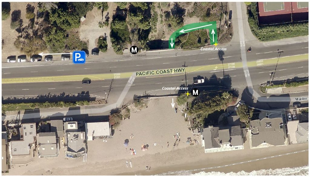
Escondido Creek Beach; 27148 Pacific Coast Highway (OPEN)
Hidden Beach (Geoffrey’s Restaurant); 27400 Pacific Coast Highway (OPEN)
Cliffside (Escondido Beach); 27420-27428 Pacific Coast Highway (OPEN)
Latigo Beach; 26500 Latigo Shore Drive (OPEN)
Lechuza Beach at East Sea Level Drive; 31544 Broad Beach Road (OPEN)
Lechuza Beach at Bunnie Lane Entrance; 31736 & 31712 Broad Beach Road (pictured above – MRCA staff photo) (OPEN)
Lechuza Beach at the intersection of West Sea Level Drive and Broad Beach Road (continue south on West Sea Level Drive once through the pedestrian gate) (OPEN)
Penelope, Cole, and Ava PCH Undercrossing (Escondido Creek Beach)
The Penelope, Cole, and Ava PCH Undercrossing at Escondido Creek Beach – Access here is always subject to tidal action. Do not use this access during Los Angeles County flash flood warnings and other emergency warnings due to increased creek flow.
West of the intersection of Via Escondido Drive and Pacific Coast Highway

MRCA-Managed Parks in the Coastal Zone
For more than 30 years, the Mountains Recreation and Conservation Authority (MRCA) and its partners the Santa Monica Mountains Conservancy, Los Angeles County, California State Parks, California Coastal Commission, State Coastal Conservancy, National Park Service and non-profit and community-based organizations, cooperatively work to provide maximum public access to beaches, coastal trails and coastal resources along the 21-mile Malibu coast and the public trail networks and parklands within the 156,000-acre Santa Monica Mountains National Recreation Area.
View Map of MRCA’s Coastal Zone Parks and Projects
MRCA’s Coastal Access Program complements the MRCA’s park, natural resource habitat protection, and the LA River programs. In addition to beach accessways, the MRCA’s Coastal Access Program includes coastal parks and trailheads across 27,000 acres of open space in the coastal zone that extend from Malibu’s beaches inland to King Gillette Ranch. The Coastal Access Program also includes planning and development of future beach accessways, parks, and trails, such as the long-envisioned 73-mile Coastal Slope Trail, a part of the statewide California Coastal Trail.
Upper Escondido Canyon – Murphy Way Coastal Overlook
Most recently, MRCA acquired 88 acres of beautiful open space with spectacular views that include the tallest waterfall in the Santa Monica Mountains, Escondido Falls. Come see your newest addition to Escondido Canyon Park and enjoy a lovely day discovering all the public trails that take you from the Santa Monica Mountains to Escondido Beach. You can see the lower falls from the Edward Albert trail off of Winding Way. To safely view the middle and upper falls from the newly-acquired parcels, please use the hiking and equestrian trail over Murphy Way that offers spectacular views of the coast and the middle and upper falls.
We need your cooperation! Please enjoy the views of the falls but do not climb to the falls to preserve the fragile habitat and avoid the risk of serious injuries.
Map: Coastal Public Access Program – Escondido Canyon Park
Map: Escondido Canyon Park to Escondido Beach
Current MRCA parks in the coastal zone include:
Cameron Nature Preserve at Puerco Canyon
Corral Canyon Park – Sara Wan Trailhead
CURRENTLY UNDER DEVELOPMENT
Ramirez Canyon Coastal Vista & Trailhead
In May 2020, the Mountains Recreation and Conservation Authority (MRCA) acquired 24-acres referred to as the Ramirez Canyon Coastal Vista & Trailhead. The park is currently closed to the public. The existing approx. one-mile loop trail and proposed trailhead amenities are not yet open and awaiting permit approval.
Contact Us
Elena Eger
elena.eger@mrca.ca.gov
310.589.3230 ext. 136


