Jump to Content  

Parks and Beach Accessways Closed by Recent Winter Storms

LOS ANGELES, CA (February 8, 2024) — The Mountains Recreation and Conservation Authority (MRCA) announced today the following parks and beach accessways are CLOSED due to damage from the recent winter rain storms:

  • Temescal Gateway Park
  • Franklin Canyon Park
  • Escondido Canyon Park
  • Corral Canyon Park
  • Carbon Beach East and West beach accessways
  • Lechuza Beach East Sea Level and Bunnie Lane/Lot (West Sea Level Drive is OPEN)
  • Hidden Beach accessway closed at beachside

The Mountains Recreation and Conservation Authority (MRCA) is a local government public entity exercising joint powers of the Santa Monica Mountains Conservancy, the Conejo Recreation and Park District and the Rancho Simi Recreation and Park District. The MRCA is dedicated to the preservation and management of local open space and parkland, wildlife habitat, coastal access, watershed lands, and trails in both wilderness and urban settings, and to ensuring access to public parkland and coastal resources. The MRCA works in cooperation with the Santa Monica Mountains Conservancy and other local government partners to acquire parkland, participate in vital planning processes, work towards wildfire resilience, and connect wildlife habitat. The MRCA manages more than 75,000 acres of parkland that it owns and that are owned by the Santa Monica Mountains Conservancy. It is one of the lead agencies revitalizing the Los Angeles


Senator Maria Elena Durazo, Assemblymember Wendy Carrillo, State Parks Director Armando Quintero Present $1.2 Million Grant to Restore Northeast Los Angeles, Antelope Valley Parkland

California State Parks Off-Highway Vehicle Grant will help MRCA prevent illegal off-roading with increased ranger patrol, barriers, and community outreach.

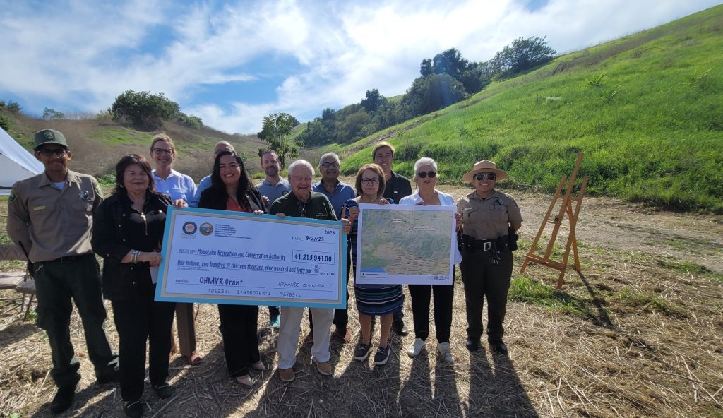
LOS ANGELES (September 27, 2023 ) – Senator Maria Elena Durazo, Assemblymember Wendy Carrillo, and State Parks Director Armando Quintero presented a giant check  for $1.2 million to the Mountains Recreation and Conservation Authority (MRCA) at a community gathering at Elephant Hills Open Space in the Northeast Los Angeles Community of El Sereno today.  The funding from the California State Parks Off-Highway Motor Vehicle Recreation Division will be used to restore three MRCA parks that have been heavily impacted recently by illegal Off-Highway Vehicle (OHV) use. The parks include Elephant Hill Open Space in the El Sereno community of Northeast Los Angeles, Ritter Ranch in the Upper Santa Clara River and Antelope Valleys, and Plum Canyon Open Space near the Santa Clara River.

“Safely managing sensitive public open space in one of the largest metropolitan areas in the nation is a team effort,” said George Lange, Chair of the Mountains Recreation and Conservation Authority Governing Board, “Our partners at California State Parks are sharing their expertise and their funding to help mitigate the damage of illegal Off-Highway Vehicles in our parks.”

As part of its restoration efforts at these locations, the MRCA will install fire gates, boulders, railings, and signage, and increase ranger patrol using site-specific off-road equipment. The aim is to reduce the impact of off-highway vehicles on sensitive areas and preserve the natural habitat for the local community to enjoy safely. Off roading activities create high wildfire ignition risk and this grant will help protect the land and communities adjacent to these open spaces. The proposed projects include areas designated by CAL FIRE as Very High Fire Severity Zones, the most severe wildfire risk designation.

Elephant Hill Open Space is part of a natural hilltop area, considered an island of habitat, in the historic Northeast Los Angeles community of El Sereno. The MRCA owns and manages eight acres along with property owned by the cities of Los Angeles and South Pasadena. “In the past few years there has been a huge increase in illegal Off-highway Vehicle use at Elephant Hill, which is in the middle of a neighborhood,” said Deputy Executive Officer Fernando Gomez, Chief Ranger of the MRCA. Illegal off-road vehicles put the park users and the vehicle drivers in danger, while causing close-in erosion and killing the habitat. This activity increases the risk of brushfire, which could be devastating to all the homes around it.”

The nonprofit Save Elephant Hill will receive $150,000 to provide community education on the social and environmental impacts of illegal OHV activities and highlight the MRCA’s restoration efforts.

“We’re very grateful to the California Off Highway Vehicle Motor Vehicle Division for providing MRCA and Save Elephant Hill an amazing opportunity to address unauthorized off-roading on Elephant Hill,” said Elva Yañez, Board President of Save Elephant Hill. “This grant allows us to partner with other community-based groups concerned about land use and the environment to increase community awareness about the damage caused by people riding trucks, motorcycles, and other vehicles on the Elephant Hill Open Space Area managed by MRCA. Our goal is to educate residents and other stakeholders about the common goal of protecting Elephant Hill’s habitat – the soil, native plants and trees, and the many species of animals and birds that make their homes here—from off-roading.”

Ritter Ranch Park is an over 4,000-acre open space park perched at the eastern end of the Sierra Pelona Mountains. The town of Acton and the upper Santa Clara River lie to the south. The Antelope Valley lies to the north and the Angeles National Forest continues westward for miles. With elevations ranging from 3,000 to 5,000 feet, this unique natural area contains plant communities indicative of a convergence of desert, mountain, and coastal influences. A system of ranch roads provide access and hiking trails throughout the park. Road access is available from both the Palmdale and Acton sides of the range.

“Illegal OHVs at Ritter Ranch destroy habitat for animals such as mountain lion and deer,” said Chief Gomez. “These new resources will help prevent soil degradation and erosion and reduce the risk of wildfire in this remote area.”

The Off-Highway Motor Vehicle Division of California State Parks manages an annual grant program to support well managed off-highway vehicle (OHV) recreation in the State of California. The program provides financial assistance to develop and maintain OHV recreation, as well as to responsibly maintain the wildlife, soils, and habitat of areas impacted by OHV use.

The Regional Forest and Fire Capacity (RFFC) Program, funded by the California Department of Conservation and California Natural Resources Agency was leveraged to create the capacity for MRCA to apply for this grant.

The Mountains Recreation and Conservation Authority (MRCA) is a local government public entity exercising joint powers of the Santa Monica Mountains Conservancy, the Conejo Recreation and Park District and the Rancho Simi Recreation and Park District. The MRCA is dedicated to the preservation and management of local open space and parkland, wildlife habitat, coastal access, watershed lands, and trails in both wilderness and urban settings, and to ensuring access to public parkland and coastal resources. The MRCA works in cooperation with the Santa Monica Mountains Conservancy and other local government partners to acquire parkland, participate in vital planning processes, work towards wildfire resilience, and connect wildlife habitat. The MRCA manages more than 75,000 acres of parkland that it owns and that are owned by the Santa Monica Mountains Conservancy. It is one of the lead agencies revitalizing the Los Angeles River.

Contact:

Dash Stolarz
Director of Public Affairs
(323) 221-9944 x198
dash.stolarz@mrca.ca.gov

Rudy J. Ortega, Jr., LHD Appointed to Mountains Recreation and Conservation Authority Governing Board

Rudy J. Ortega, Jr., LHD is the first Native American to Serve on the Mountains Recreation and Conservation Authority Governing Board

LOS ANGELES, CA (July 17, 2023) The Mountains Recreation and Conservation Authority (MRCA) announced today that Rudy J. Ortega, Jr., LHD has been appointed by the Santa Monica Mountains Conservancy to the Governing Board of the MRCA. Ortega, Jr. currently serves as the Chairperson of the Conservancy as an appointee of the Governor. The first Native American to serve on the MRCA Governing Board, Ortega, Jr.  is the Tribal President of the Fernandeño Tataviam Band of Mission Indians, a native sovereign nation of northern Los Angeles County. As the elected leader of his Tribe, Ortega Jr. oversees the governmental body and manages affairs pertaining to the rights of all Fernandeño Tataviam tarahat (people).

“My ancestry is thousands of years buried here, in this soil,” said Ortega, Jr.  “The dirt, the mountains, the plants all contain my ancestral DNA. I am pleased to now join the MRCA as the first California Native American and to be part of an agency that works on preservation and management of open space and parklands for all generations.”

Ortega, Jr. is a member of Siutcabit, the lineage of present-day Encino, CA. His ancestors come from the villages that originated in the geographical areas of Santa Clarita Valley, Simi Valley, and San Fernando Valley. His great-grandfather Antonio Maria Ortega, from whom he receives his traditional role as tomiar or leader, fought in Los Angeles Superior Court in the 19th century to preserve traditional lands and protect Native title to Mexican land grants from encroaching settlers. His father, the late Rudy Ortega Sr., served as the previous leader of the Tribe for over fifty years and was elected to the Los Angeles City/County Native American Indian Commission in 1977. Following his father’s leadership, Ortega Jr. was appointed to the Native American Indian Commission by Mayor James Hahn in 2004, where he serves today as a commissioner.

From 2004 – 2018, Ortega Jr. invigorated the Tribe’s non-profit Pukúu Cultural Community Services as the Executive Director. Through this role, he served the greater Los Angeles County American Indian community and oversaw Haramokngna American Indian Cultural Center. Through his seat as Tribal President, Ortega Jr. helped establish the Tataviam Land Conservancy, Paséki Strategies Corporation, and a co-management agreement with the City of San Fernando for Rudy Ortega Sr. Park.

In addition to serving as Chairperson of the Conservancy, Ortega Jr. is a member of the Los Angeles River Master Plan Steering Committee, Santa Clarita Watershed Recreation and Conservation Authority, Edison Consumer Advisory Panel Board, and a Commission member of the Climate Emergency Mobilization Committee appointed by Mayor Eric Garcetti.

The Mountains Recreation and Conservation Authority (MRCA) is a local government public entity exercising joint powers of the Santa Monica Mountains Conservancy, the Conejo Recreation and Park District and the Rancho Simi Recreation and Park District. The MRCA is dedicated to the preservation and management of local open space and parkland, wildlife habitat, coastal access, watershed lands, and trails in both wilderness and urban settings, and to ensuring access to public parkland and coastal resources. The MRCA works in cooperation with the Santa Monica Mountains Conservancy and other local government partners to acquire parkland, participate in vital planning processes, work towards wildfire resilience, and connect wildlife habitat. The MRCA manages more than 75,000 acres of parkland that it owns and that are owned by the Santa Monica Mountains Conservancy. It is one of the lead agencies revitalizing the Los Angeles River.

Los Angeles River Recreation Zones Open for Tenth Season

The public is welcome to kayak, walk, and fish on two sections of the river managed by the Mountains Recreation and Conservation Authority in Elysian Valley and at the Sepulveda Basin in Encino through September 30, 2023.

LOS ANGELES (May 29, 2023) — The Mountains Recreation and Conservation Authority (MRCA) announced today that the Los Angeles River Recreation Zones in Elysian Valley and the Sepulveda Basin are open for their tenth season starting on Memorial Day May 29, 2023.

The L.A. River Recreation Zones provide access to recreate on and explore the Los Angeles River in two different parts of the river that are still in a natural state with activities including steerable boating such as kayaking and canoeing, fishing and bird watching. The River Recreation Zones are managed by the MRCA in coordination with the City of Los Angeles, the Army Corps of Engineers, and the County of Los Angeles. Before the season began, the MRCA commissioned a nesting bird and sensitive species survey to ensure there would be no conflict between the recreational use of the river and the abundant bird life in the recreation zones.

By opening the Elysian Valley and Sepulveda Basin recreation zones, the City of Los Angeles continues to promote the L.A. River as a premier community destination – providing safe and equitable public access and recreational opportunities that aims to bring all members of the Los Angeles community together.

“The L.A. River connects so many different parts of the City to nature, we at LASAN will continue to do our part to keep the River clean and healthy for all Angelenos in years to come,” said L.A. Sanitation and Environment (LASAN) Director and General Manager Barbara Romero.

As a reminder, swimming is not allowed in the L.A. River. Before every visit, visitors are encouraged to check the L.A. River water quality and conditions at the LASAN website: https://lacitysan.org/waterquality

Hours are sunrise to sunset every day, except during and after inclement weather or other adverse conditions. The Recreation Zones will be open through September 30, 2023. For the most up to date information go to the River Recreation Zone website www.lariverrecreation.org.

The Sepulveda Basin Recreation Zone is a gentle, two-mile up-river and back trip with braided channels, wildlife, and tranquil pools. Of the two Recreation Zones, the Sepulveda Basin offers easy paddling, and less natural obstacles. Kayakers in the Sepulveda Basin will be able to access the Los Angeles River from Burbank Boulevard west of Woodley Avenue. There is plenty of street parking on Woodley Avenue.

The Elysian Valley kayak experience is a five-mile, one-way trip with braided channels and abundant wildlife in the middle of the city. The kayak experience sometimes includes strong currents and a few rapids – you may fall out of your kayak while traveling through them. Boulders and other obstacles are also part of the experience. Be aware that you will likely be getting off your kayak and pulling it through the water to get around rocks in areas.

To access the Elysian Valley Recreation Zone, Kayakers can enter the Los Angeles River from MRCA Rattlesnake Park at Fletcher Drive. Parking is available on Fletcher Drive. Access is also available upstream from MRCA Lewis MacAdams Riverfront Park (formerly Marsh Park) with parking lot entrances are at 2999 Rosanna St. and 2944 Gleneden Street. Public Restrooms are available.

“We are looking forward to operating the tenth season of the LA River Recreation Zone,” said MRCA Chief Ranger, Fernando Gomez. “Please remember to take appropriate safety precautions when going out on the river. You must wear a personal flotation device and a helmet. Also, use sunscreen and drink plenty of water. You will be in the sun.”

About Mountains Recreation and Conservation Authority
The Mountains Recreation and Conservation Authority is a local public park agency dedicated to the preservation and management of open space, urban parkland, watershed lands, trails, and wildlife habitat. The MRCA manages more than 80,000 acres of public parkland and provides natural resources and scientific expertise, critical regional planning services, operations, fire prevention and ranger services, as well as education and leadership programs for thousands of youth each year. It is one of the lead agencies revitalizing the Los Angeles River.

About LA Sanitation and Environment
As the lead agency for the City’s environmental programs and initiatives, Sanitation protects public health and the environment through the administration and management of three program areas: Clean Water (Wastewater), Solid Resources (Solid Waste Management) and Watershed Protection (Stormwater). These infrastructure programs collect, treat, dispose and recycle the solid and liquid waste generated by the nation’s second largest city of more than four million residents. Through these essential Public Works programs, Sanitation delivers a triple bottom line of economic, environmental and social benefits that sustain quality of life in Los Angeles.

About L.A. City Department of Public Works
The Department of Public Works is comprised of five bureaus:  Contract Administration, Engineering, Sanitation, Street Lighting, and Street Services, as well as the Offices of the Board, including the Offices of Community Beautification, Filming and Petroleum Administration. More than 6,000 employees are responsible for design, construction, renovation and operation of public projects ranging from bridges to wastewater treatment plants and libraries; curbside collection and graffiti removal; and maintenance of streets, sidewalks, sewers, streetlights and street trees.

The Department is governed by the Board of Public Works (BPW), a five-member full-time executive team that is committed to delivering projects and programs that enhance quality of life, economic growth, public health and the environment to all Angelenos. For more information, please visit  http://bpw.lacity.org.

Sheila James Kuehl Nature Preserve at Ladyface Mountain Dedicated

 325-acre Parkland Viewed by thousands of daily motorists on Kanan Road at the gateway to the Santa Monica Mountains named for stand-out legislator who protected open space and parkland for all

 AGOURA HILLS, CA (May 21,2023) – Congresswoman Julia Brownley, State Senator Fran Pavley (ret.), Los Angeles County Supervisor Zev Yaroslavsky (ret.) and Agoura Hills Mayor Chris Anstead were among the speakers and nearly a hundred community members under a canopy of oak trees at a ceremony this morning to name the breathtaking 325-acre parkland in honor of the extraordinary Sheila James Kuehl. Just south of the intersection of Kanan and Agoura Roads in Agoura Hills, a new park sign identifies the open space familiar to thousands of daily motorists traveling to and from Pacific Coast Highway.

Sheila James Kuehl has been recognized by her peers as one of the most effective elected officials in California. After serving two terms on the Los Angeles County Board of Supervisors, Supervisor Kuehl retired in December 2022. Kuehl had previously served eight years in the State Senate (2000-2008) and six years in the State Assembly (1994-2000), the first openly gay person elected to the Legislature. During this time, she was a Legislative Participant on the Santa Monica Mountains Conservancy. In all her elected offices, Kuehl represented the Santa Monica Mountains and the Coast, and championed the preservation and protection of open space as well as public access. During her tenure, thousands of acres of open space were protected including Upper Las Virgenes Open Space Preserve, King Gillette Ranch, and Corral Canyon Park.

As a Los Angeles County Supervisor, in addition to dedicating funding for hundreds of acres of additional open space, Kuehl presided over the adoption of the County’s updated Santa Monica Mountains North Area Plan which maximizers preservation of the area’s natural environment.

Supervisor Kuehl was an early and vociferous advocate and funder for the public protection of the open space, that until today, had been known as Triangle Ranch (named for the shape of the landholding). Kuehl understood its ecological significance and its prominence as a gateway to the Santa Monica Mountains. Supervisor Kuehl secured $2.5 million in County Proposition A funds for the Phase 1 acquisition in 2018. For Phase 4 of the project, Kuehl secured more than $ 1.4 million in Calabasas Landfill Economic Recovery Funds from the Los Angeles County Sanitation District, crucial for the completion of the transaction.

Sheila James Kuehl Nature Preserve at Ladyface Mountain connects the approximately 1,000-acre Ladyface Mountain core habitat area with the Liberty Canyon inter-mountain range wildlife corridor, and Malibu Creek State Park. The property includes broad swaths of coast live oak woodland, chaparral, purple sage scrub, native and annual grassland, and valley oak savannah as well as a significant population of the federally-listed annual wildflower Lyon’s pentachaeta and the succulent Agoura Hills dudleya.. Many rock outcroppings contain unique microsites for plants and animals.

Mountain lion, mule deer, American badger, bobcat, gray fox, ring-tailed cat, long-tailed weasel, California quail, and dozens of reptile varieties are among the animal species supported by the rugged terrain. The parkland is only a short distance from the Wallis Annenberg Wildlife Crossing over the 101 Freeway which is expected to be completed in 2024.

The Mountains Recreation and Conservation Authority (MRCA) is a local government public entity dedicated to the preservation and management of open space and parkland, watershed lands, trails, and wildlife habitat. The MRCA works in cooperation with other government partners to acquire parkland, participate in vital planning processes, provide natural resources and scientific expertise, and complete major park improvement projects. The MRCA manages and provides ranger services and fire protection for almost 80,000 acres of parkland that it owns and that are owned by the Santa Monica Mountains Conservancy or other agencies and provides comprehensive education and interpretation and leadership programs for youth. It is one of the lead agencies providing for the revitalization of the Los Angeles River.


Public, Private Partners Secure Permanent Protection of Banning Ranch

California Natural Resource Agency, Mountains Recreation and Conservation
Authority, Trust for Public Land, and Banning Ranch Conservancy Announce the
Permanent Protection of Banning Ranch

Los Angeles, CA – Today, the Trust for Public Land (TPL) in partnership with the California Natural
Resources Agency (CNRA), Mountains Recreation and Conservation Authority (MRCA) and Banning
Ranch Conservancy (BRC) announced the completed acquisition of Banning Ranch.

Equivalent in size to 4.5 Disneylands and overlooking the Pacific Ocean, the 387-acre property
between the cities of Costa Mesa, Newport Beach and Huntington Beach has long been eyed for
development. The tribal and local community’s decades long advocacy and TPL’s five-year, $100
million conservation campaign helped bring to a close a chapter of private ownership and begin a
new chapter of community driven public and tribal access and future restoration on what is
considered the last large, unprotected coastal property in Southern California.

“Millions of Californians will soon be able to enjoy this remarkable new open space overlooking the
Pacific Ocean,” said California Natural Resources Secretary Wade Crowfoot. “This includes
residents from nearby communities with precious few parks and open spaces. It’s a great example
of what we’re capable of doing in California through creative partnerships.”

TPL and BRC worked to secure public and private funds – including a $50 million
lead donation from philanthropists and longtime Orange County residents Frank and Joan Randall
– to purchase the property and support the conservation effort. The Randall family’s generous
donation was complemented by broad support from State agencies including the Wildlife
Conservation Board ($15.5 million), CNRA ($14 million), State Coastal Conservancy ($11.5 million),
and the California Department of Fish and Wildlife ($8 million).

“Completing this conservation project was a once-in-a-lifetime opportunity and would not have
been possible without the incredible generosity of Frank and Joan Randall, combined with the
leadership and support of the Governor, local and state elected officials, tribal and community
advocates, and our state funding partners. We can now officially say this land will become
California’s next public coastal park,” said Guillermo Rodriguez, TPL’s California State Director and
Vice President-Pacific Region.

Thanks to leadership and advocacy through consultation from local California Native American
tribes and important tribal community advocates, this property will ensure future protection of
cultural resources and accessibility to local tribal communities. This property is within the
ancestral homelands of local California Native American tribes including the Acjachemen and
Tongva peoples and continues to have important significance since time immemorial. The site and
the nearby Fairview Park and surrounding bluff areas along the Santa Ana River are believed to
have been part of a native village site known as Geŋa.

“The Juaneno Band of Mission Indians is looking forward to collaborating with MRCA during all
phases of the project. We are also excited to see what the future holds and in regaining an area for
us to hold ceremony. Geŋa hold a special place in our hearts. We are thrilled to be able to share
with the public the importance of this village, not only to the Acjachemen but to our plant and
animal relatives as Cho’onom noneskinum (to all my relations),” Chairwoman Heidi Lucero, CEO
Juaneño Band of Mission Indians, Acjachemen Nation.

Project partners envision turning the property into a vast public park and preserve that would
provide coastal access with trails, low-cost camping and picnic sites. It is an anchor property within
a nearly 1,000-acre network of protected natural lands linked by bike and walking trails and is
easily accessed by public transportation.

The project also protects critical biological diversity. There are approximately 100 acres of
marshes, mudflats, and riparian scrub, and 67 acres of coastal sage scrub, with critical habitat for
as many as five endangered species. Protecting this property from development and repurposing it
from oil extraction to public purposes aligns with California’s ambitious climate goals and the
Governor’s “30 x 30 Initiative” that calls for the protection of 30% of the state’s land and coastal
waters by 2030. Restoring the property can help mitigate impacts from sea level rise, sequester
carbon in area wetlands, reduce the urban heat island through restoration efforts and provide
habitat for native species while also allowing appropriate public access, all of which are key
priorities in the Initiative.

As the property’s public land steward, MRCA will hold title while the previous oil operator
undertakes at its own expense a two-to-three year process of remediation, including removal of oil
infrastructure from the property, including incorporating brownfield bioremediation. During this
time, no public access will be allowed, but a stewardship/management planning effort will be
underway. Robust tribal consultation and community engagement will be incorporated into the
development of a property management plan to inform tribal access and engagement, habitat
restoration and public access plans. MRCA will also work with California Native American tribes
and tribal community members who hold the property as their ancestral homeland to develop the
tribal access and engagement plan that honors, elevates and protects tribal history, cultural
resources, and tribal access.

Part of the Tribal Access and Engagement Plan involves a tribal selection of a formal name to
reflect the cultural significance and ancestral homeland of the local California Native American
tribes, as well as “The Frank and Joan Randall Park & Preserve”.
“Thank you to landowners Newport Banning Ranch and Aera Energy for their hard work. We would
not be where we are today without their commitment and patience. And, having the support of and
leadership from Assemblymember Cottie Petrie-Norris was very impactful to this conservation
success,” said Conservancy President Terry M. Welsh, MD. “Now that the land is protected, BRC
transitions to a new role of restoration and stewardship for the Preserve and nearby coastal lands
and waters. We can’t wait to get started!”

“With sweeping coastal views and fantastic recreational and habitat restoration opportunities, The
Frank and Joan Randall Preserve will serve 8.4 million people who live within an hour’s drive and
marks a monumental step forward in helping to close the park equity gap in Southern
California,” said Guillermo Rodriguez, TPL California State Director. “Now we bring to a close a
chapter of private ownership and begin an exciting new chapter recognizing and elevating the
ancestral homelands of local Native American tribes combined with community driven public access
and restoration.”

TPL, as part of the transaction, is also awarding MRCA a $2 million grant to seed the future
stewardship of the property.

Mountains Recreation and Conservation Authority Acquires Some of the Most Visually Stunning and Botanically Sensitive Open Space in the City of Agoura Hills

Visible to thousands of daily motorists on the 101 Freeway and surrounding parklands, the Cornerstone property expands the Liberty Canyon Wildlife Corridor and protects a segment of the Rim of the Valley Trail with immediate trail connections to the Santa Monica Mountains.


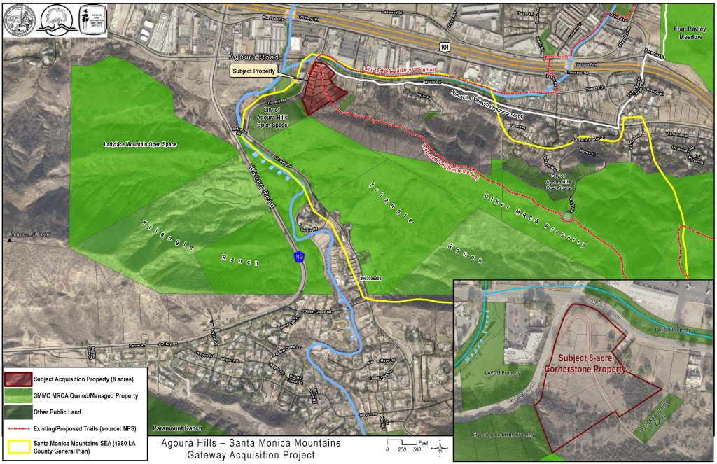
AGOURA HILLS, CA (December 30, 2022) — The Mountains Recreation and Conservation Authority (MRCA) announced today that escrow had closed on the acquisition of the regionally significant 8.2-acre Cornerstone property on the southeast corner of Agoura Road and Cornell Road in the city of Agoura Hills. At one time approved for a development of 35 residential apartment units plus retail, restaurant, and office space, the new parkland abuts hundreds of acres of protected open space owned by the MRCA and the City including the western approach of the in-construction Wallis Annenberg Wildlife Crossing at Liberty Canyon south of the 101 Freeway.


Acquisition of the beautiful property, which is at the tip of a huge conservation area traversed by multiple species including deer, bobcat, and mountain lion, was secured by a $2,300,000 grant from the State Wildlife Conservation Board and a $330,000 grant from the Santa Monica Mountains Conservancy.


“If you lived in the Agoura area over 40 years ago, as I did,” recalled retired Assemblymember and State Senator Fran Pavley, who was the first Mayor of Agoura Hills, “you knew this environmentally sensitive prominent hill with majestic oaks, Cornerstone, because our only market and post office were located across the street at what is now the Whizin Arcade. “We voted to incorporate our community in 1982 to protect open space, native plants and oaks, and develop responsibly. We recognized our position to provide a major gateway to the Santa Monica Mountains for all people.

“Our City’s first grant was from the also young Santa Monica Mountains Conservancy. It was to begin a hiking and equestrian trail from the Cornerstone property east to Old Agoura and south towards Paramount Ranch. The Executive Director of the Conservancy, Joe Edmiston, and I—then in our 30’s—along with other local leaders—climbed to the top of Ladyface mountain and looked down at Cornerstone and the other land that we might save for wildlife and people. It is gratifying to know that public preservation of this irreplaceable open space has finally happened thanks to the efforts of many local residents, the Native Plant Society, the Santa Monica Mountains Conservancy, and the State Wildlife Conservation Board.”


After years of contention, including a successful 2020 legal challenge won by the California Native Plant Society and the local community group Save the Agoura Cornell Knoll, the now permanently protected parkland contains some of the most visually and botanically sensitive land in the area including the federally listed Agoura Hills dudleya, the California ESA candidate species crotch bumble bee, and the Ojai navarretia as well as Coast live oak and scrub oak woodland. Majestic views, including that of Ladyface Mountain, abound. Los Angeles County designated the property as part of the Santa Monica Mountains SEA (Significant Ecological Area) and the property forms part of the northern gateway to the Santa Monica Mountains National Recreation Area.


A segment of the Rim of the Valley Trail identified in the NPS Trail Plan, and LA County Regional Trail System already exists on the property and will link with the City of Agoura Hills Linear Park Trail proposal and the existing Paramount Ranch Connector Trail.


The Mountains Recreation and Conservation Authority (MRCA) is a local government public entity dedicated to the preservation and management of open space and parkland, watershed lands, trails, and wildlife habitat. The MRCA works in cooperation with other government partners to acquire parkland, participate in vital planning processes, provide natural resources and scientific expertise, and complete major park improvement projects. The MRCA manages and provides ranger services and fire protection for almost 80,000 acres of parkland that it owns and that are owned by the Santa Monica Mountains Conservancy or other agencies and provides comprehensive education and interpretation and leadership programs for youth. It is one of the lead agencies providing for the revitalization of the Los Angeles River.

# # #

6,000 Acres of Prime Open Space in Northern Los Angeles County Now Protected

FOR IMMEDIATE RELEASE

July 7, 2022

Media Contacts:

Albert Lundeen, California Natural Resources Agency

(916) 628-5467


6,000 Acres of Prime Open Space in Northern Los Angeles County Now Protected

 Acquisition of Hathaway/Temescal Ranch advances California’s 30×30 conservation goals

SACRAMENTO — The largest undeveloped private property in Los Angeles County is now part of a protected ecological area that will preserve habitat and expand wildlife corridors between the San Gabriel, Sierra Madre and Santa Susanna mountains. It also moves California a step closer in its effort to conserve 30 percent of the state’s land and coastal waters by 2030, often referred to as the 30×30 initiative.

The Hathaway/Temescal Ranch property, 6,006 acres of open space, is 40 miles west of downtown Los Angeles and adjacent to both the Angeles National Forest and the Los Padres National Forest between Castaic Reservoir and Lake Piru.

“This is a big deal,” said California Secretary for Natural Resources Wade Crowfoot. “This acquisition will help preserve biodiversity, expand outdoor access for Angelenos, and sequester carbon as we combat climate change. It’s just the kind of creative, voluntary action that is driving our 30×30 movement across California.”

Hathaway/Temescal Ranch is land that has been used for ranching and grazing, but other than a modest ranch home, it is undeveloped. The property includes wetlands, rolling hills and is within the flight path for condors from the nearby Sespe Condor Sanctuary.

“In the Southern California landscape, securing 6,000 acres is extraordinary, especially 6,000 acres that provide prime linkage between protected spaces, and with major water resources,” said Chair of the Governing Board of the Mountains Recreation and Conservation Authority (MRCA) George Lange. “The MRCA will continue to work together with federal, State, and local government, our nonprofit partners, and landowners to preserve and protect critical open space for the public benefit.”

The property was acquired in three phases by the nonprofit Trust for Public Land, and transferred to the Mountains Recreation and Conservation Authority, a local government agency exercising joint powers of the Santa Monica Mountains Conservancy, and the Conejo and Rancho Simi Recreation and Park Districts.

“After nearly three decades, it’s incredible to finally be able to celebrate the protection of Temescal Ranch, one of the largest contiguous stretches of land ever conserved in Los Angeles County, that not only will bring a wide network of hiking and biking trails close to home for Los Angeles residents but will protect some of California’s most unique coastal sage scrub and chaparral ecosystems,” said California State Director and Vice President-Pacific Region for Trust for Public Land Guillermo Rodriguez. “We’re proud to have worked with our dedicated partners at MRCA and thankful to the support of our private donors and public funders to ensure permanent access to this unique and beautiful landscape.”

The California Wildlife Conservation Board was key to acquiring the land and funded almost half of the purchase, including $3.5 million in voter-approved Proposition 117 funds to secure the final phase.

The property sits within a Los Angeles County-designated “Significant Ecological Area.” It helps create critical east to west linkage between the San Gabriel and Sierra Madre mountains as well as a north to south linkage between the Sierra Madre and Santa Susanna mountains, both highlighted in the South Coast Missing Linkages Project, which is a comprehensive plan for a regional network that would maintain and restore critical habitat linkages between existing reserves. These linkages form the backbone of a conservation strategy for Southern California.

The acquisition is another step forward toward California’s 30×30 conservation goals. This commitment is part of an international movement to protect nature across the planet, which now includes 90 countries that have adopted 30×30 targets.

In April, the California Natural Resources Agency released Pathways to 30×30: Accelerating Conservation of California’s Nature, responding to Governor Gavin Newsom’s nature-based solutions executive order, which identified California’s lands as a critical yet underutilized sector in the fight against climate change.

Pathways to 30×30 outlines a roadmap, including land purchases such as the Hathaway/Temescal Ranch property, to achieve the state’s first-in-the-nation 30×30 land conservation goal. California has conserved 24 percent of its land and 16 percent of coastal waters to date. To reach 30 percent by 2030, the state’s strategy lays out several concurrent pathways, including accelerating regionally led conservation, buying strategic lands for conservation and access, expanding voluntary conservation easements, and aligning investments to maximize conservation benefits. Empowering local and regional partners is essential to achieve this target, and the strategy establishes a 30×30 Partnership to organize this coordination and collaboration.

Scientists from around the world agree that conserving one-third of the planet by 2030 is needed to combat climate change, protect people from climate impacts, and to limit the mass extinction of plant and animal life. It also represents a historic opportunity to strengthen the human connection to nature, especially for communities that have historically lacked access, including those in populous counties such as Los Angeles.

###

The Los Angeles River Recreation Zone Opens its Ninth Season on Memorial Day, May 30, 2022

The public is welcome to kayak, walk, and fish on two sections of the river managed by the Mountains Recreation and Conservation Authority in Elysian Valley and at the Sepulveda Basin in Encino.

LOS ANGELES (May 26, 2022) — The Mountains Recreation and Conservation Authority (MRCA) announced today that the Los Angeles River Recreation Zones in Elysian Valley and the Sepulveda Basin will open for their ninth season on Memorial Day, May 30, 2022.

The L.A. River Recreation Zones provide access to recreate on and explore the Los Angeles River in two different parts of the river that are still in a natural state with activities including steerable boating such as kayaking and canoeing, fishing and bird watching. The River Recreation Zones are managed by the MRCA in coordination with the City of Los Angeles Bureau of Sanitation and Councilmember Mitch O’Farrell, the Army Corps of Engineers, and the County of Los Angeles.

Hours are sunrise to sunset every day, except during and after inclement weather or other adverse conditions. The Recreation Zones will be open through September 30, 2022.

“We are looking forward to another great season,” said MRCA Chief Ranger, Fernando Gomez. “We urge everyone to check out the website www.lariverrecreation.org to find out about river conditions, water quality, weather, and closure information. You can also learn about how to access the river, and outfitters who provide guided tours or rent kayaks.”

The Sepulveda Basin Recreation Zone is a gentle, two-mile up-river and back trip with braided channels, wildlife, and tranquil pools. Of the two Recreation Zones, the Sepulveda Basin offers easy paddling, and less natural obstacles. Kayakers in the Sepulveda Basin will be able to access the Los Angeles River from Burbank Boulevard west of Woodley Avenue. There is plenty of street parking on Woodley Avenue.

The Elysian Valley kayak experience is a five-mile, one-way trip with braided channels and abundant wildlife in the middle of the city. The kayak experience sometimes includes strong currents and a few rapids – you may fall out of your kayak while traveling through them. Boulders and other obstacles are also part of the experience. Be aware that you will likely be getting off your kayak and pulling it through the water to get around rocks in areas. New this year will be the opportunity to kayak under the recently opened, 400-foot Taylor Yard Bridge that connects cyclists and pedestrians from Cypress Park to Elysian Valley across the LA River.

To access the Elysian Valley Recreation Zone, Kayakers can enter the Los Angeles River from MRCA Rattlesnake Park at Fletcher Drive. Parking is available on Fletcher Drive. Access is also available upstream from MRCA Lewis MacAdams Riverfront Park (formerly Marsh Park) whose parking lot entrances are at 2999 Rosanna St. and 2944 Gleneden Street. Public Restrooms are available.

“Everyone needs to remember to take safety precautions when going out on the river,” said Chief Gomez. “You must wear a Personal Flotation Device (PFD) and wear a helmet. Use sunscreen and drink plenty of water.”

The Mountains Recreation and Conservation Authority is a local public park agency dedicated to the preservation and management of open space, urban parkland, watershed lands, trails, and wildlife habitat. The MRCA manages more than 75,000 acres of public parkland and provides natural resources and scientific expertise, critical regional planning services, operations, fire prevention and ranger services, as well as education and leadership programs for thousands of youth each year. It is one of the lead agencies revitalizing the Los Angeles River.

Santa Monica Mountains Conservancy and Mountains Recreation Authority Acquire Public Land Over 30 Years to Protect the Liberty Canyon Wildlife Corridor

AGOURA, CA (April 21, 2022) — Tomorrow the Wallis Annenberg Wildlife Crossing will break ground at a celebration at the MRCA’s Las Virgenes Open Space Trailhead. The MRCA originally purchased the public parkland in 1999 as part of a long-term acquisition strategy by the Santa Monica Mountains Conservancy and the MRCA to protect the critical habitat of the Santa Susana Mountains, the Simi Hills, and the Santa Monica Mountains.

In 1990, the Santa Monica Mountains Conservancy commissioned the study “Critical Wildlife Corridor Habitat Linkage Areas between the Santa Susana Mountains, the Simi Hills and the Santa Monica Mountains.” Furthering Dr. Michael Soule’s earlier work for the Santa Monica Mountains National Recreation Area on habitat linkages, the study identified the site of the Liberty Canyon Wildlife Crossing as the choke point necessary to connect the Santa Monica Mountains across the 101 Freeway to the Simi Hills in order to prevent the local mountain lion population from extinction.

At that time, most of the property in this landscape choke point was privately owned, and the future of preserving this critical inter-mountain range habitat linkage was anything but certain. Over the next thirty years, the Santa Monica Mountains Conservancy, and its joint powers partner, the Mountains Recreation and Conservation Authority as well as the National Park Service, systematically acquired much of the private land identified in the 1990 study using voter-approved funds, and permanently protected a critical mass of habitat that will now make it possible to link the mountains with the Liberty Canyon Wildlife Crossing.

THE SANTA MONICA MOUNTAINS CONSERVANCY is a State Agency that was established by the California Legislature in 1980. Its mission is to strategically buy back, preserve, protect, restore, and enhance treasured pieces of Southern California to form an interlinking system of urban, rural, and river parks, open space, trails and wildlife habitat that is easily accessible to the public.

THE MOUNTAINS RECREATION AND CONSERVATION AUTHORITY (MRCA) is a local public parks agency exercising joint powers of the Santa Monica Mountains Conservancy, the Conejo Recreation and Park District, and the Rancho Simi Recreation and Park District. The MRCA operates and manages all parkland that it owns and that is owned by the Santa Monica Mountains Conservancy.

Together, the MRCA and Santa Monica Mountains Conservancy have helped to preserve over 80,000 acres of urban and wilderness parkland.